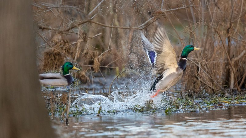
Arkansas Wildlife Waterfowl Report
BY Jim Harris
ON 11-27-2019
Nov. 27, 2019
Jim Harris
Managing Editor Arkansas Wildlife Magazine
Few Mallards Have Arrived, According to Last Week’s Aerial Survey
LITTLE ROCK – Arkansas Game and Fish Commission staff conducting the November 2019 aerial waterfowl surveys last week estimated more than 681,000 ducks in the Arkansas Delta, but fewer than 250,000 of them were mallards, a count similar to the 2009-2019 long-term November average.
The observers conducted surveys Nov. 16-19 in the Mississippi Alluvial Valley (the Delta), Nov. 18 in the Arkansas River Valley, and Nov. 19 in southwest Arkansas. Along with the Delta count, a total of about 36,000 ducks were seen the Arkansas River Valley, including fewer than 10,000 mallards. The southwest Arkansas total duck count was 17,193, including more than 8,000 mallards. Observers in the Delta estimated more than 1 million light (lesser snow and Ross’s) geese and slightly more than 400,000 greater white-fronted geese (specklebellies).
While the mallard count in the Delta was along the lines of the 2009-2019 long-term average, total duck population estimates were about 100,000 ducks fewer than the long-term average. Observers estimated over 40 percent of mallards in the Delta in the Cache survey zone (almost entirely in the northern portion of the zone), with another 16 percent in the Little River Ditches zone; thus, more than 50 percent of all Delta mallards were in the northern reaches of the Delta during this survey. Primary mallard hot spots were limited to portions of Craighead, Greene and Poinsett Counties, along with Big Lake National Wildlife Refuge and Wildlife Management Area (WMA). Duck concentrations noted by observers included these hot spots along with the Dave Donaldson Black River WMA habitat complex, including Lake Ashbaugh and surrounding agricultural lands.
The trend of slightly lower total ducks on average and about normal in mallards was also found in the River Valley observations, with the highest mallard and total duck estimates in the Frog Bayou survey zone. About half the ducks observed in southwest Arkansas were mallards, and observers noted most ducks along the Red River habitat corridor.
Observers noted 50 percent of mallards in the Delta in agricultural fields (mostly rice), followed by scrub-shrub and moist-soil habitats. In the Arkansas River Valley, biologists saw nearly half of mallards in oxbow lakes and about 20 percent in moist-soil habitats. Multiple cold fronts, including one that set records for low temperatures, preceded this survey period, so expectations were set for high duck counts. However, survey estimates indicated only average mallard numbers and below-average total duck numbers.
“Anecdotally, unmanaged habitat appeared to be high (in duck numbers) during the 7-10 days before surveys began and following extreme cold temperatures and obvious migration events,” Luke Naylor, the AGFC waterfowl program coordinator, said. “Much of this habitat disappeared from the landscape by the time of this survey, particularly in the central Delta, and this habitat decline was exacerbated by warming temperatures and south winds that likely urged ducks north. In contrast, flooding on agricultural lands in the north Delta remained good as farmers captured water in their fields and provided important habitat. Duck numbers reflect this habitat availability: estimates were high in the north Delta while noticeably low south of a line that roughly corresponds with U.S. Highway 64, including regions that are historic strongholds for ducks and duck habitat.”
AGFC survey observers were J.J. Abernathy, Jason Carbaugh, Jason Jackson, Cameron Tatom and Alex Zachary. Staff will conduct the next aerial waterfowl survey the week of Dec. 16.
Northeast Arkansas
Big Lake WMA
Map | Water Gauge | Weather Report
When the Ditch 81 extension gauge near Manila (upstream of the Big Lake north-end control structure) reads 17.5 feet, water is beginning to come over the north levee degrade on Big Lake WMA. When the Ditch 81 Extension gauge reads 18.0 feet or higher, the water level on the WMA will rise quickly and hunters should exercise caution while on the area. Be aware of underwater logs in boat runs and hangers in trees.
UPDATE: The North water control structure is operational, and flooding of the WMA has proceeded.
North Woods GTR
Habitat: Mast production is good.
Water Level: Bo Dock guage currently reads 237,8feet msl; target level is 235.5 feet with 100% flooded.
South Woods GTR
Habitat: Mast production is fair.
Water Level: The 7-Mile gauge is currently at 236.8 feet msl; target level is 234.5 feet with 100 percent flooded.
Simmons Field
Habitat: A good amount of millet and sedge is present. Seed production is very good in north unit, middle field, and south field was stripped in Japanese millet with strips of wild millet and sedge that did extremely well. On Nov. 22, one-third of the north field and one-third of the middle field for stripped-rolled with a cleated roller.
Water Level: 100% coverage.
Dave Donaldson Black River WMA
Map | Water Gauge | Weather Report
Waterfowl hunters should be aware of hangers and submerged logs within the boat runs and GTRs. Please exercise caution when accessing the area. Please remember to keep boats off the levees so AGFC personnel can access the area. Boats blocking access will be moved. Unattended trailers are not to be left overnight on parking areas. River level is 10.87 feet and rising.
Upper Island GTR
Habitat: Mast crop is moderate within the GTRs.
Water Level: Above target level, 100% flooded.
Lower Island GTR
Habitat: Mast crop is moderate within the GTRs.
Water Level: Above target level, 100% flooded.
Upper Reyno GTR
Habitat: Mast crop is moderate within the GTRs.
Water Level: Above target level, 100% flooded.
Lower Reyno GTR
Habitat: Mast crop is moderate within the GTRs.
Water Level: Above target level, 100% flooded.
Winchester GTR
Habitat: Mast crop is moderate within the GTRs.
Water Level: Above target level, 100% flooded.
Earl Buss Bayou DeView WMA
Map | Water Gauge | Weather Report
Boaters should use caution while using the Thompson Tract boat run.
South Oliver GTR
Habitat: Mast production has been good.
Water Level: 40% flooded with a current gauge reading of 0.4 feet. Water level is currently rising in this GTR.
Thompson Tract GTR
Habitat: Mast production has been good.
Water Level: 100% flooded with a current gauge reading of 1.9 feet.
Lake Hogue WRA
Habitat: Primarily deep open water habitat.
Water Level: Normal pool level.
Shirey Bay Rainey Brake WMA
Map | Water Gauge | Weather Report
Waterfowl hunters should be aware of hangers and submerged logs within the boat runs and GTRs. Please exercise caution when accessing the area. In addition, hunters should allow safe passage when parking vehicles along roadsides. Vehicles blocking access will be moved.
Adam Brake GTR
Habitat: Good abundance of mast crop within the GTR.
Water Level: Water level is 239.6 feet msl with a target level of 240.0 msl. 75% flooded.
Rainey Brake GTR
Habitat: Good abundance of mast crop within the GTR.
Water Level: 100% flooded.
Eagle Pond GTR
Habitat: Good abundance of mast crop within the GTR.
Water Level: 80% flooded.
Phase III Moist-Soil Unit
Habitat: Good wetland-type vegetation.
Water Level: 40% flooded.
Charles Crisp Moist-Soil Unit
Habitat: Good wetland-type vegetation.
Water Level: 65% flooded.
Ward Field Moist-Soil Unit
Habitat: Good wetland-type vegetation.
Water Level: 45% flooded.
River Field Moist-Soil Unit
Habitat: Good wetland-type vegetation.
Water Level: 60% flooded.
St. Francis Sunken Lands WMA
Map | Water Gauge | Weather Report
Hunt Area
Habitat: Mast production is good within the hunt area.
Water Level: Water levels on St. Francis Sunken Lands for waterfowl season are dependent on flows from St. Francis River. The target level for providing huntable timber is 212.0 feet msl read from the Oak Donnick gauge. As of Nov. 26, levels were 213.73 feet msl.
Snowden WRA
Habitat: Mixed grasses.
Water Level: 10% flooded, mostly in the low-lying areas due to rain.
Payneway WRA
Habitat: A, B, C D pools have mixed smartweed and barnyard grasses. Mowing was completed for open water use in pools B and C. Moderate mast is available within pools A, B and C as well.
Water Level: Pool A is at 10% coverage. Pool B is at 10%. Pool C is at 20%. Pool D is at 45%.
bar
East-Central Arkansas
Henry Gray Hurricane Lake WMA
Map | Water Gauge | Weather Report
Hunters should call the Wildlife Hotline at 800-440-1477 for current road closures.
North GTR
Habitat: Good mast crop.
Water Level: The current Glaise Creek reading is 192.99 feet msl.
Note: All structures on the North GTR are closed.
South GTR
Habitat: Fair mast crop.
Water Level: The current Glaise Creek reading is 192.99 feet msl.
Note: All structures on the South GTR are open.
Rex Hancock Black Swamp WMA
Map | Water Gauge | Weather Report
Hunters should call the Wildlife Hotline at 800-440-1477 for current road closures.
Main WMA
Habitat: Good mast crop.
Water Level: 75% flooded due to flooding on Cache River. (Currently the Cache River level is 9.05 feet on the Patterson Gauge and is projected to rise to 9.5 feet by Nov. 28).
Wyeville Unit
Habitat: Good stand of millet and native vegetation,
Water Level: 100% coverage.
Sheffield Nelson Dagmar WMA
Map | Water Gauge | Weather Report
The Conway George units ar now open for hunting. Please visit www.agfc.com for maps, special regulations, permit application and draw dates. Hunters should call the Wildlife Hotline at 800-440-1477 for current road closures.
Mud Slough GTR
Habitat: Good mast crop.
Water Level: 40% coverage.
Apple Lake WRA
Habitat: Good mast crop.
Water Level: 100%
Conway George Waterfowl Unit A
Habitat: Good stand of millet and native vegetation.
Water Level: 70%
Conway George Waterfowl Unit B
Habitat: Natural slough area with beneficial wetland palnts.
Water Level: 70%
Conway George Waterfowl Unit C
Habitat: Good stand of millet and native vegetation.
Water Level: 70%
Steve N. Wilson Raft Creek Bottoms WMA
Map | Water Gauge | Weather Report
Unit A
Habitat: Excellent stand of native vegetation.
Water Level: 100% coverage.
Unit B
Habitat: Excellent stand of millet and native vegetation.
Water Level: 100%
Unit C
Habitat: Good stand of native vegetation.
Water Level: 90%
Unit D (Youth Area)
Habitat: Good stand of native vegetation.
Water Level: 100%
Unit E
Habitat: Excellent stand of millet and native vegetation.
Water Level: 85%
Unit F
Habitat: Good stand of millet and native vegetation.
Water Level: 45%
Unit G
Habitat: Fair stand of millet and native vegetation.
Water Level: 80%
Unit H (Mobility-impaired blind)
Habitat: Excellent stand of native vegetation.
Water Level: 100%
Unit I
Habitat: Habitat conditions are poor.
Water Level: 65%
Unit J (Cypert Tract)
Habitat: Excellent stand of native vegetation.
Water Level: 100%
Unit K (Cypert Tract)
Habitat: Excellent stand of native vegetation.
Water Level: 60%
Unit L (Cypert Tract)
Habitat: Excellent stand of native vegetation.
Water Level: 0%
Central Arkansas
Bell Slough WMA
Map | Weather Report
The Bell Slough GTR is primarily rainfall dependent with the exception of a limited amount of water that the AGFC can back in and catch from Palarm Creek.
Bell Slough GTR
Habitat: Moderate mast crop.
Water Level: 100% flooded. Full pool at closure due to Lake Conway release.
Palarm Creek WRA Units 1&2
Habitat: Millet was planted as a cover crop this year following disking within the moist-soil units.
Water Level: 80% flooded.
Craig D. Campbell Lake Conway Reservoir
Map | Weather Report
Habitat and water levels are normal on both Pierce and Dix creeks.
Cypress Bayou WMA
Hunt Area
Habitat:
Good mast crop
Water Level: 75% coverage.
Red Cut Slough Tract
Unit 1
Habitat: Good stand of millet and native vegetation.
Water Level: 50%
Unit 2
Habitat:
Excellent Sstand of millet and native vegatation.
Water Level: 25%
Unit 3
Habitat:
Good stand of millet and native vegetation.
Water Level: 75%
Unit 4
Habitat:
Good stand of millet and native vegetation.
Water Level: 80%
Unit 5
Habitat:
Good stand of millet and native vegetation.
Water Level: 30%
Unit 6
Habitat:
Good stand of millet and native vegetation.
Water Level: 30%
Harris Brake WMA
Harris Brake Upper Unit
Habitat: Good hard mast production within the GTR.
Water Level: 80%
Harris Brake Lower Unit
Habitat: Good hard mast production within the GTR.
Water Level:
40% flooded.
Holland Bottoms WMA
Hunt Area
Habitat: Good mast crop.
Water Level: 70%
Lake Pickthorne WRA
Habitat: Excellent conditions.
Water Level: East cell is 100% coverage. West cell is 45%.
Northwest Arkansas
Dardanelle WMA
McKennon Bottoms (half-day hunting)
Habitat: Heavy stand of perennial vegetation due for disking next spring.
Water Level: 50% and currently pumping.
Potter’s Pothole Hartman Waterfowl Unit (half-day hunting)
Habitat: Some planted millet, good stand of native millet, sprangle top, panic grasses.
Water Level: 100%
Ed Gordon Point Remove WMA
Due to continued rainfall events, most waterfowl impoundments on Ed Gordon Point Remove WMA are somewhere between 50% flooded and full pool at this time. Duck use on the WMA has been fair and hunter success has been moderate to good.
Little Hole (Unit 1)
Habitat: Naive vegetation.
Water Level: 90% flooded.
Willow Island (Unit 2)
Habitat: Planted Japanese millet.
Water Level: 60%
Red Gate (Unit 3)
Habitat: Naive vegetation.
Water Level: 100%
Pig Trough (Units 4 and 5)
Habitat: Native vegetation and Japanese and Chiwappa millet.
Water Level: 70%
Cedar Ridge (Unit 6)
Habitat: Japanese and Chiwappa millet, native vegetation.
Water Level: 70%
Unit 7a
Habitat: Japanese millet, native vegetation.
Water Level: 100%
Unit 7b
Habitat: Native vegetation.
Water Level: 100%
Duck Trap (Units 8a, 8b and 8c)
8a
Habitat: Native vegetation.
Water Level: 80%
8b
Habitat: Japanese and Chiwappa millet, native vegetation.
Water Level: 70%
8c
Habitat: Japanese millet.
Water Level: 50%
Unit 9
Habitat: Japanese millet.
Water Level: 50%
Controversy Corner (Unit 10)
Habitat: Native vegetation.
Water Level: 100%
Remmel Marsh
Habitat: Planted Japanese millet, native vegetation.
Water Level: 80%
Mud Pond (Unit 12)
Habitat: Native vegetation.
Water Level: 100%
Turkey Pond (Units 13a, 13b and 13c)
13a
Habitat: Native vegetation and Japanese millet.
Water Level: 50%
13b
Habitat: Native vegetation.
Water Level: 70%
13c
Habitat: Japanese and Chiwappa millet, native vegetation.
Water Level: 50%
Teeny Pond (Unit 15)
Habitat: Native vegetation.
Water Level: 100%
Salt Lick (Unit 15)
Habitat: Native vegetation.
Water Level: 100%
Bobby’s Pond (Unit 16)
Habitat: Japanese millet.
Water Level: 100%
Race Track (Unit 17)
Habitat: Native vegetation.
Water Level: 100%
Frog Bayou WMA (half-day hunting)
Unit 1
Habitat: Sprangle top, wild millet, smartweed and nutsedge
Water Level: 100%
Unit 2
Habitat: Good stand of barnyard grass and nutsedge.
Water Level: 50%
Unit 3
Habitat: Smartweed, toothcup, nutsedge, barnyard grass, sprangle top and duck potato.
Water Level: 100%
Unit 4
Habitat: Barnyard grass, sprangle top, annual smartweed, nutsedge and crabgrass.
Water Level: 100%
Unit 5
Habitat: Sprangle top, wild millet, smartweed, knotgrass, nutsedge and duck potato..
Water Level: 100%
Unit 6
Habitat: Barnyard grass, smartweed, crabgrass and sprangle top.
Water Level: 100%
Unit 7
Habitat: Lower end of unit planted with millet, upper end with barnyard grass, sprangle top and smartweed.
Water Level: 75% and scheduled to pump full the first week of December.
bar
Galla Creek WMA
Galla Creek GTR
Habitat: Moderate stand of native vegetation, including a mixture of barnyard grass and sprangle top. Duck use and hunter success on the WMA has been moderate.
Water Level: 50% flooded.Staged flooding of the impoundment began on Nov. 12.
Nimrod Lloyd Millwood WMA
Nimrod GTR
Habitat: This area produced a great mast crop this year with a mix of moderage to good stands of desirable native vegetation throughout the open lands.
Water Level: 30% flooded.
Ozark Lake WMA/Dyer Lake Water Unit
Dyer Lake Cells (half-day hunting)
Habitat: Fair stand of nutsedge and toothcup and smartweed, and sprangle top. Unit 3 was impacted by summer flooding and in need of disturbance that is scheduled for next year.
Water Level: Units 1 and 2, 100%. Units 3 (rainfall dependent) 100%,
Petit Jean River WMA
Map | Water Gauge | Weather Report
Sorehead Moist-Soil Unit
Habitat: This unit contains a mix of moderate to good stands of desirable native vegetation throughout..
Water Level: 100%
Black Lands Moist-Soil Unit
Habitat: This area contains a mix of poor to great stands of desirable native vegetation throughout. The wooded areas inside the unit produced a great mast crop this year.
Water Level: 100%
Slaty Crossing Moist-Soil Unit
Habitat: Due to ongoing waterfowl habitat enhancement projects this unit has only small stands of native vegetation. The majority of this unit is bare ground.
Water Level: 5%
Black Lands Duck Area
Habitat: The wooded sections of this area produced a great mast crop this year. This area also contains a mix of moderate to great stands of desirable native vegetation mixed throughout.
Water Level: 100%
Pullen Pond Marsh
Habitat: Due to ongoing waterfowl habitat enhancement projects, parts of the southern and western sections of this area are bare ground. The western section of this area has spotted sections of great desirable native vegetation. The northern section of the area only produced poor stands of native vegetation.
Water Level: 50%.
Pond Creek GTR
Habitat: This area produced a great mast crop this year with great stands of desirable mative vegetation in the open lands within this area,
Water Level: 10%.
Slaty GTR
Habitat: This area produced a great mast crop this year.
Water Level: 5%
Santa Fe GTR
Habitat: This area produced a great mast crop this year.
Water Level: 100%
Southwest Arkansas
Dr. Lester Sitzes III Bois d’Arc WMA
Bois d’Arc Lake WRA
Habitat: Closed to hunting.
Water Level: Normal
Red Slough WRA
Habitat: Closed to hunting.
Water Level: 10%
GTR
Habitat: Good mast production.
Water Level: 0%.
Little Grassy
Habitat: Good
Water Level: 60%
Millwood Lake
Map | Water Gauge | Weather Report
Habitat: Habitat conditions are good.
Water Level: 260.18 feet msl.
Ozan WMA
Unit 1
Habitat: Good
Water Level: 0%
Unit 2
Habitat: Good
Water Level: 0%
Unit 3
Habitat: Good
Water Level: 0%
Unit 4
Habitat: Good
Water Level: 0%
Unit 5
Habitat: Good
Water Level: 0%
Sulphur River WMA
Mercer Bayou
Habitat: Fair
Water Level: Low, no boat access.
Henry Moore WRA
Habitat: Closed to hunting.
Water Level: 10%
Southeast Arkansas
Beryl Anthony Lower Ouachita WMA
Map | Weather Report
Habitat: The WMA has a good hard mast production.
Water Level: The only water on the WMA currently is in the sloughs and in the oxbow lakes.
Cut-Off Creek WMA
Hunt Area
Habitat: Habitat conditions are good.
Water Level: 0% flooded.
Pigeon Creek WRA
Habitat: Habitat conditions are good.
Water Level: 0% flooded.
Freddie Black Choctaw Island WMA Deer Research Area
Map | Water Gauge | Weather Report
Habitat conditions are good. Flooding is river dependent. Click on the Water Gauge link above for current Mississippi River levels. Use extreme caution when boating in river.
George H. Dunklin Jr. Bayou Meto WMA
Upper Vallier GTR
Habitat: Good
Water Level: 178.2 feet msl, full pool at 180 feet msl.
Lower Vallier GTR
Habitat: Good
Water Level: 178.1 feet msl, full pool at 179 feet msl.
Government Cypress GTR
Habitat: Good
Water Level: 178.4 feet msl, full pool at 179 feet msl.
Buckingham Flats GTR
Habitat: Good
Water Level: 176.2 msl. First phase of pumping completed.
Temple Island GTR
Habitat: Good
Water Level: 20% flooded. First phase of pumping ongoing, pump was out of service for 4 days.
Canon Brake
Habitat: Good
Water Level: 171.1 msl. Full pool at 177 msl.
Halowell WRA
Habitat: Excellent
Water Level: Staggered flooding of units. 50% flooded, good duck usage on south units.
Wrape Plantation WRA
Habitat: Excellent
Water Level: Staggered flooding of units.
Seven Devils WMA
Hunt Area
Habitat: Habitat conditions are good.
Water Level: Below gauge. Water levels are variable depending on Cut-Off Creek levels.
Trusten Holder WMA
Map | Water Gauge | Weather Report
Habitat conditions are good. Flooding is river dependent. Click on the Water Gauge link above for current Arkansas River levels.
Recent News
AGFC Commissioner Meeting Notice
Apr. 16, 2024
Subscribe to Our Weekly Newsletter E-mails
Don’t miss another issue. Sign up now to receive the AGFC Wildlife Weekly Newsletter in your mailbox every Wednesday afternoon (Waterfowl Reports are published weekly during waterfowl season and periodically outside the season). Fishing Reports arrive on Thursdays. Fill in the following fields and hit submit. Thanks, and welcome!