Arkansas Wildlife Waterfowl Report
BY Jim Harris
ON 12-12-2018
Dec. 12, 2018
Jim Harris
Managing Editor Arkansas Wildlife Magazine
Waterfowl Hunters Still Awaiting Big Push of Ducks
LITTLE ROCK – The weather north of Arkansas seemed to be conducive to pushing the migration of ducks south into The Natural State over the past weekend, but most reports fielded early this week indicated the wait is still on.
“I have not seen a notable push,” said Arkansas Game and Fish Commission biologist Jacob Bokker, who reports weekly from the east-central Arkansas region, which includes such public hunting areas as the Steve N. Wilson Raft Creek Bottoms WMA. The AGFC’s Terrence Teel, who reports on the WMAs in northeast Arkansas all the way down to Bayou DeView, said Wednesday, “No great flocks that I am aware of yet.”
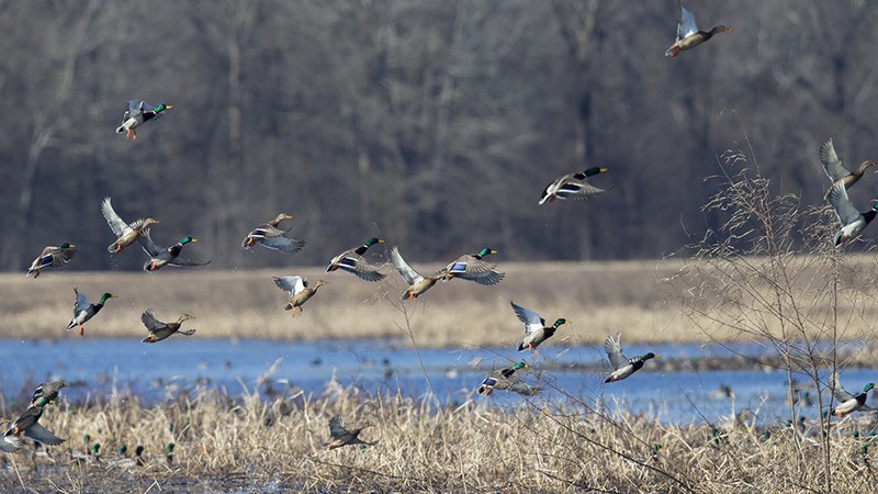
Reports from the Big Lake National Wildlife Refuge in the northeast corner of the state were that the NWR was holding an average number of ducks for this time of year. In south-central Arkansas, observers noted a good amount of ducks in all units of Hallowell Reservoir in Arkansas County (see photo above). And in the St. Francis Sunken Lands WMA in northeast Arkansas, a fair number of birds reportedly are in the area this week, with large numbers of geese.
Water is in ample supply when the big numbers eventually reach Arkansas. There are no dry greentree reservoirs this year before mid-December, and in most spots reported this week there is 100 percent coverage. Where the Waterfowl Report notes that an area is “100% flooded,” that means that the entire acreage has water coverage; it doesn’t mean that there is too much water to negotiate the area with waders (or that the water is too high for hunting), contrary to some questions we’ve fielded from would-be waterfowl hunters.
Nevertheless, the large amount of rainfall Arkansas saw last week raised levels of rivers, lakes and bayous throughout the state. The Felsenthal NWR in deepest south Arkansas, thanks to the rising Ouachita River, has plenty of water. The river is also flooding Beryl Anthony Lower Ouachita WMA, and ducks are reportedly using the backwater areas. The WMA water coverage is less than 25 percent as of Monday, which is one of the less covered hunting areas in the WMA system.
The AGFC’s Jason Carbaugh told Ducks Unlimited, “In Northeast Arkansas, all of our wildlife management areas are now 100 percent flooded, and all of our greentree reservoirs are at full pool.”
Little seems to have changed from Arkansas since the November waterfowl aerial survey, which showed fewer than 900,000 ducks in the state. Meanwhile, reports from Missouri last week by waterfowl observers said the Show Me State had around 900,000 mallards using public managed properties, with peak numbers in the northern part of the state.
Andy Raedeke, a waterfowl biologist with the Missouri Department of Conservation, told Ducks Unlimited, “We certainly are at or near peak levels. While the numbers are impressive, it’s almost equally remarkable that the ducks are still here considering what we’ve had for weather.”
Thus brings the big question among waterfowlers of why hasn’t that wintry weather across the midwest pushed those peak numbers of birds further down the flyways.
Luke Naylor, the AGFC’s waterfowl program coordinator, has been expecting Arkansas to begin to see bigger migration numbers starting mid-December. “We’re in that middle ground right now where ducks are just bouncing around,” he said last week. “I don’t hear any great reports from anywhere that folks are seeing any big influx of ducks. This is truly not that abnormal for right now. The normal peak migration is still a week or so away.”
With the White and Cache rivers running fairly high after recent heavy rainfall, ducks may be focused more on those major water sources, observers note.
We did receive some good reports late last week of a few excellent rice field hunts in Arkansas County, which were helped by the heavy overcast and misting-to-raining conditions that lingered through Saturday. However, on the bayous and in green timber of that region, it tended to be a mixed bag of wet hunting: ringnecks, woodducks and mergansers mixed in with gadwalls and an occasional mallard.
Northeast Arkansas
Big Lake WMA
Map | Water Gauge | Weather Report
When the Ditch 81 extension gauge near Manila (upstream of the Big Lake north-end control structure) reads 17.5 feet, water is beginning to come over the north levee degrade on Big Lake WMA. When the Ditch 81 Extension gauge reads 18.0 feet or higher, the water level on the WMA will rise quickly and hunters should exercise caution while on the area. Be aware of underwater logs in boat runs and hangers in trees.
Big Lake NWR is holding an average number of ducks for this time of year.
North Woods GTR
Habitat: Mast production is fair.
Water Level: Bo Dock gauge currently reads 236.6 feet msl. Target level is 235.5 feet with 100% flooded.
South Woods GTR
Habitat: Mast production is fair.
Water Level: The 7-Mile gauge is currently at 235.8 feet msl. Target level is 234.5 feet with 100% flooded.
Simmons Field
Habitat: A good amount of millet, smartweed and sedge is present. Seed production is very good in north unit, middle field was planted in Chawapa millet coverage is fair, south field was stripped in Chawapa millet fair with strips of smartweed that did extremely well.
Water Level: 100% coverage.
Dave Donaldson Black River WMA
Map | Water Gauge | Weather Report
Waterfowl hunters should be aware of hangers and submerged logs within the boat runs and GTRs. Please exercise caution when accessing the area. Please remember to keep boats off the levees so AGFC personnel can access the area. Boats blocking access will be moved. Unattended trailers are not to be left overnight on parking areas.
Upper Island GTR
Habitat: Below-average abundance of mast crop within the GTRs.
Water Level: Water level is 269.88 feet msl. Target level is 269.5 feet msl. 100% flooded.
Lower Island GTR
Habitat: Below-average abundance of mast crop within the GTRs.
Water Level: Water level is 268.78 feet msl. Target level is 268.0 feet msl. 100% flooded.
Upper Reyno GTR
Habitat: Below-average abundance of mast crop within the GTRs.
Water Level: Water level is 267.48 feet msl. Target level is 266.9 feet msl. 100% flooded.
Lower Reyno GTR
Habitat: Below-average abundance of mast crop within the GTRs.
Water Level: Water level is 266.3 feet msl. Target level is 266.3 feet msl. 100% flooded.
Winchester GTR
Habitat: Below-average abundance of mast crop within the GTRs.
Water Level: Water level is 263.58 feet msl. Target level is 263.7 feet msl. 95% flooded.
Earl Buss Bayou DeView WMA
Map | Water Gauge | Weather Report
Boaters should use caution while using the Thompson Tract boat run. A few ducks and geese are moving through the area.
South Oliver GTR
Habitat: Mast production has been good.
Water Level: 100% flooded with a current gauge reading of 1.8 feet.
Thompson Tract GTR
Habitat: Mast production has been good.
Water Level: 100% flooded with a current gauge reading of 1.9 feet.
Lake Hogue WRA
Habitat: Primarily deep open water habitat.
Water Level: Normal pool level.
Shirey Bay Rainey Brake WMA
Map | Water Gauge | Weather Report
Waterfowl hunters should be aware of hangers and submerged logs within the boat runs and GTRs. Please exercise caution when accessing the area. In addition, hunters should allow safe passage when parking vehicles along roadsides. Vehicles blocking access will be moved.
Adam Brake GTR
Habitat: Good abundance of mast crop within the GTR.
Water Level: Water level is 240.0 feet msl with a target level of 240.0 msl. 100% flooded.
Rainey Brake GTR
Habitat: Good abundance of mast crop within the GTR.
Water Level: 100% flooded.
Eagle Pond GTR
Habitat: Good abundance of mast crop within the GTR.
Water Level: 100% flooded.
Phase III Moist-Soil Unit
Habitat: Good wetland-type vegetation.
Water Level: 95% flooded.
Charles Crisp Moist-Soil Unit
Habitat: Good wetland-type vegetation.
Water Level: 80% flooded.
Ward Field Moist-Soil Unit
Habitat: Good wetland-type vegetation.
Water Level: 100% flooded.
River Field Moist-Soil Unit
Habitat: Good wetland-type vegetation..
Water Level: 95% flooded.
St. Francis Sunken Lands WMA
Map | Water Gauge | Weather Report
Hunt Area
Habitat: Mast production is average within the hunt area.
Water Level: Water levels on St. Francis Sunken Lands for waterfowl season are dependent on flows from St. Francis River. The target level for providing huntable timber is 212.0 feet msl read from the Oak Donnick gauge. As of Dec. 10, levels were 1.05 feet above target at 213.05 feet msl. Fair number of birds are in the area this week, with large numbers of geese.
Snowden WRA
Habitat: There was a small green up response of wetland plants after the growing season burns throughout the unit.
Water Level: 10% flooded, mostly in the low-lying areas due to rain.
Payneway WRA
Habitat: Pool D has 14 acres of buckwheat providing good bugging areas when water becomes available. A,B,C pools have sunflowers left standing with some smartweed response underneath. Barrows have been mowed for open-water use.
Water Level: Pool A is at 10%. Pool B is at 25% coverage. Pool C is at 20%. Pool D is at 50%.
East-Central Arkansas
Henry Gray Hurricane Lake WMA
Map | Water Gauge | Weather Report
Hunters should call the Wildlife Hotline at 800-440-1477 for current road closures.
North GTR
Habitat: Good mast crop.
Water Level: The current Glaise Creek reading is 192.60 feet msl.
Note: All structures on the North GTR are closed.
South GTR
Habitat: Fair mast crop.
Water Level: The current Glaise Creek reading is 192.60 feet msl.
Note: All structures on the South GTR are open.
Rex Hancock Black Swamp WMA
Map | Water Gauge | Weather Report
Hunters should call the Wildlife Hotline at 800-440-1477 for current road closures.
Main WMA
Habitat: Good mast crop.
Water Level: 100%.
Wyeville Unit
Habitat: Good stand of millet and native vegetation.
Water Level: 85% coverage.
Sheffield Nelson Dagmar WMA
Map | Water Gauge | Weather Report
The Conway George units are available by applying for online permits. Please visit www.agfc.com for maps, special regulations, permit application and draw dates. Hunters should call the Wildlife Hotline at 800-440-1477 for current road closures.
Mud Slough GTR
Habitat: Good mast crop.
Water Level: 80%.
Apple Lake WRA
Habitat: Good mast crop.
Water Level: 100%.
Conway George Waterfowl Unit A
Habitat: Good stand of millet and native vegetation.
Water Level: 100%
Conway George Waterfowl Unit B
Habitat: Natural slough area with beneficial wetland plants
Water Level: 100%
Conway George Waterfowl Unit C
Habitat: Good stand of millet and native vegetation.
Water Level: 100%
Steve N. Wilson Raft Creek Bottoms WMA
Map | Water Gauge | Weather Report
Unit A
Habitat: Excellent stand of millet and native vegetation.
Water Level: 100% coverage.
Unit B
Habitat: Excellent stand of millet and native vegetation.
Water Level: 100%
Unit C
Habitat: Good stand of native vegetation.
Water Level: 100%
Unit D (Youth Area)
Habitat: Good stand of millet and native vegetation.
Water Level: 100%
Unit E
Habitat: Excellent stand of millet and native vegetation.
Water Level: 100%
Unit F
Habitat: Good stand of millet and native vegetation.
Water Level: 100%
Unit G
Habitat: Fair stand of millet and native vegetation.
Water Level: 100%
Unit H (Mobility-impaired blind)
Habitat: Excellent stand of millet and native vegetation.
Water Level: 100%
Unit I
Habitat: Habitat conditions are poor.
Water Level: 100%
Unit J (Cypert Tract)
Habitat: Excellent stand of millet and native vegetation.
Water Level: 100%
Unit K (Cypert Tract)
Habitat: Excellent stand of native vegetation.
Water Level: 40%
Unit L (Cypert Tract)
Habitat: Good stand of native vegetation.
Water Level: 5%
Central Arkansas
Bell Slough WMA
Map | Weather Report
The Bell Slough GTR is primarily rainfall dependent with the exception of a limited amount of water that the AGFC can back in and catch from Palarm Creek.
Bell Slough GTR
Habitat: Poor mast crop.
Water Level: 100%.
Palarm Creek WRA
Habitat: Millet was planted as a cover crop this year following disking within the moist-soil units.
Water Level: 100%
Craig D. Campbell Lake Conway Reservoir
Map | Weather Report
Habitat and water levels are normal on both Pierce and Dix creeks.
Cypress Bayou WMA
Hunt Area
Habitat: Good mast crop.
Water Level: 100% coverage.
Red Cut Slough Tract
Unit 1
Habitat: Good stand of millet and native vegetation.
Water Level: 95%
Unit 2
Habitat: Excellet stand of millet and native vegetation.
Water Level: 45%
Unit 3
Habitat: Good stand of millet and native vegetation.
Water Level: 80%
Unit 4
Habitat: Good stand of millet and native vegetation.
Water Level: 90%
Unit 5
Habitat: Good stand of millet and native vegetation.
Water Level: 45%
Unit 6
Habitat: Good stand of millet and native vegetation.
Water Level: 45%
Harris Brake WMA
Harris Brake Upper Unit
Habitat: Fair mast crop mixed in with native vegetation.
Water Level: 95%
Harris Brake Lower Unit
Habitat: Fair mast crop mixed in with native vegetation.
Water Level: 100%
Holland Bottoms WMA
Hunt Area
Habitat: Good mast crop.
Water Level: 70% coverage.
Lake Pickthorne WRA
Habitat: Excellent.
Water Level: East cell is 100% coverage. West cell is 100%.
Northwest Arkansas
Dardanelle WMA
McKennon Bottoms (half-day hunting)
Habitat: Good stand of native moist-soil vegetation.
Water Level: 100%.
Potter’s Pothole Hartman Waterfowl Unit (half-day hunting)
Habitat: Excellent stand of millet.
Water Level: 100%
Ed Gordon Point Remove WMA
Map | Weather Report
Most waterfowl impoundments on Ed Gordon Point Remove WMA are at full pool at this time. Duck use on the WMA has beeb low to moderate. Hunter success has been poor to fair.
Little Hole (Unit 1)
Habitat: Natural vegetation.
Water Level: 100%
Willow Island (Unit 2)
Habitat: Natural vegetation.
Water Level: 100%
Red Gate (Unit 3)
Habitat: Natural vegetation.
Water Level: 100%
Pig Trough (Units 4 and 5)
Habitat: Natural vegetation.
Water Level: 100%
Cedar Ridge (Unit 6)
Habitat: Natural vegetation and Japanese and Chiwappa millet.
Water Level: 85%
Unit 7a
Habitat: Japanese and Chiwappa millet.
Water Level:100%
Unit 7b
Habitat: Natural vegetation.
Water Level: 100%
Duck Trap (Units 8a, 8b and 8c)
8a
Habitat: Natural vegetation and Japanese and Chiwappa millet.
Water Level: 100%
8b
Habitat: Natural vegetation and Japanese and Chiwappa millet.
Water Level: 100%
8c
Habitat: Natural vegetation and Japanese and Chiwappa millet.
Water Level: 100%
Unit 9
Habitat: Natural vegetation and Japanese and Chiwappa Millet.
Water Level: 100%
Controversy Corner (Unit 10)
Habitat: Natural vegetation and Japanese and Chiwappa millet.
Water Level: 100%
Remmel Marsh
Habitat: Natural vegetation and Japanese and Chiwappa millet.
Water Level: 100%
Mud Pond (Unit 12)
Habitat: Natural vegetation.
Water Level: 100%
Turkey Pond (Units 13a, 13b and 13c)
13a
Habitat: Natural vegetation and Japanese and Chiwappa millet.
Water Level: 100%
13b
Habitat: Natural vegetation.
Water Level: 100%
13c
Habitat: Natural vegetation and Japanese and Chiwappa millet.
Water Level: 100%
Teeny Pond (Unit 14)
Habitat: Natural vegetation.
Water Level: 100%
Salt Lick (Unit 15)
Habitat: Natural vegetation.
Water Level: 100%
Bobby’s Pond (Unit 16)
Habitat: Natural vegetation.
Water Level: 100%
Race Track (Unit 17)
Habitat: Natural vegetation.
Water Level: 100%
Frog Bayou WMA (half-day hunting)
Unit 1
Habitat: Sprangle top crabgrass, wild millet and smartweed.
Water Level: 100%
Unit 2
Habitat: Poor moist-soil response due to August flood.
Water Level: 100%
Unit 3
Habitat: Smartweed, toothcup, wild millet and sprangle top.
Water Level: 100%
Unit 4
Habitat: Wild millet, sprangle top, smartweed, nut sedge and crabgrass.
Water Level: 100%
Unit 5
Habitat: Sprangle top, wild millet and smartweed.
Water Level: 100%
Unit 6
Habitat: Wild millet, smartweed and crabgrass.
Water Level: 100%
Unit 7
Habitat: Smartweed, wild millet and sprangle top.
Water Level: 100%
Galla Creek WMA
Galla Creek GTR
Habitat: Excellent stand of natural vegetation, including a mixture of barnyard and smartweed.
Water Level: 95%, staged flooding of the impoundment began on Nov. 15. Duck use on the WMA has been generally low.
Nimrod Lloyd Millwood WMA
Nimrod GTR
Habitat: Fair mast crop mixed in with native vegetation.
Water Level: 40%.
Ozark Lake WMA/Dyer Lake Water Unit
Dyer Lake Cells (half-day hunting)
Habitat: Soy been stubble and native vegetation.
Water Level: Units 1 and 2, 100%. Units 3 and 4 are rainfall dependent and have little water in them now.
Petit Jean River WMA
Map | Water Gauge | Weather Report
Santa Fe GTR
Habitat: Fair mast crop mixed in with native vegetation.
Water Level: 100%
Olin Cain/Sore Head Moist-Soil Unit
Habitat: Good stand of native vegetation.
Water Level: 100%
Black Lands Moist-Soil Unit
Habitat: Good stand of native vegetation.
Water Level: 100%
Slaty Crossing Moist-Soil Unit
Habitat: Fair stand of native vegetation.
Water Level: 95%
Pullen Pond
Habitat: Half of area has a fair stand of native vegetation, other half of area has 100 acres of Japanese millet.
Water Level: 50%.
Pond Creek GTR
Habitat: Fair mast crop mixed in with native vegetation.
Water Level: 10%.
Slaty Pond GTR
Habitat: Fair mast crop mixed in with native vegetation.
Water Level: 10%
Black Lands Duck Area
Habitat: Millet mixed in with good native vegetation.
Water Level: 100%
Southwest Arkansas
Dr. Lester Sitzes III Bois d’Arc WMA
Bois d’Arc Lake WRA
Habitat: Closed to hunting.
Water Level: Normal
Red Slough WRA
Habitat: Closed to hunting.
Water Level: 15%
GTR
Habitat: Good mast production.
Water Level: 100%.
Little Grassy
Habitat: Good.
Water Level: 75%
Millwood Lake
Map | Water Gauge | Weather Report
Habitat: Habitat conditions are good.
Water Level: 261.59 feet msl.
Ozan WMA
Unit 1
Habitat: Good
Water Level: 60%
Unit 2
Habitat: Good
Water Level: 50%
Unit 3
Habitat: Good
Water Level: 60%
Unit 4
Habitat: Good
Water Level: 80%
Unit 5
Habitat: Good
Water Level: 5%
Sulphur River WMA
Mercer Bayou
Habitat: Fair.
Water Level: 198.6 feet msl (full pool is 199.0 feet msl).
Henry Moore WRA
Habitat: Closed to hunting.
Water Level: 70%.
Southeast Arkansas
Beryl Anthony Lower Ouachita WMA
Map | Weather Report
Habitat: The WMA has a good hard mast production.
Water Level: The Ouachita River is once again flooding the WMA. Ducks are using the backwater areas. The WMA is less than 25% flooded.
Cut-Off Creek WMA
Hunt Area
Habitat: Habitat conditions are good.
Water Level: 100% flooded.
Pigeon Creek WRA
Habitat: Habitat conditions are good.
Water Level: 100% flooded.
Freddie Black Choctaw Island WMA Deer Research Area
Map | Water Gauge | Weather Report
Habitat conditions are good. Flooding is river dependent. Click on the Water Gauge link above for current Mississippi River levels. Use extreme caution when boating in river.
George H. Dunklin Jr. Bayou Meto WMA
Upper Vallier GTR
Habitat: Good
Water Level: 179.8 feet msl, full pool at 180 feet msl.
Lower Vallier GTR
Habitat: Good
Water Level: 179.5 feet msl, full pool at 179 feet msl.
Government Cypress GTR
Habitat: Good
Water Level: 179.5 feet msl, full pool at 179 feet msl.
Buckingham Flats GTR
Habitat: Good
Water Level: 100% flooded.
Temple Island GTR
Habitat: Good
Water Level: 100% flooded.
Canon Brake
Habitat: Good
Water Level: 100% flooded.
Halowell WRA
Habitat: Excellent
Water Level: Staggered flooding of units. 85% flooded, good duck usage on all units.
Wrape Plantation WRA
Habitat: Excellent
Water Level: Staggered flooding of units.
Seven Devils WMA
Hunt Area
Habitat: Habitat conditions are good
Water Level: 133.0 feet msl. 100% flooded.
Trusten Holder WMA
Map | Water Gauge | Weather Report
Habitat conditions are good. Flooding is river dependent. Click on the Water Gauge link above for current Arkansas River levels.
Recent News
Arkansas Wildlife Weekly Fishing Report
Apr. 18, 2024
Subscribe to Our Weekly Newsletter E-mails
Don’t miss another issue. Sign up now to receive the AGFC Wildlife Weekly Newsletter in your mailbox every Wednesday afternoon (Waterfowl Reports are published weekly during waterfowl season and periodically outside the season). Fishing Reports arrive on Thursdays. Fill in the following fields and hit submit. Thanks, and welcome!